
Report of the Investigations at Site 5MT2
By Richard H. Wilshusen and Stephen H. Lekson
Site 5MT2 consists of two small pueblos with occupations dating to Pueblo III (A.D. 1150-1300). The site is on a small rise just 40 m to the northeast of the Porter roomblock area of Site 5MT1 and approximately 40 m northeast of an unnumbered pueblo. The other two sites have occupations dating between late Pueblo II and Pueblo III, and as discussed in the site setting section there may be between two to five contemporary households living at these sites at certain times between A.D. 1120 and 1280.
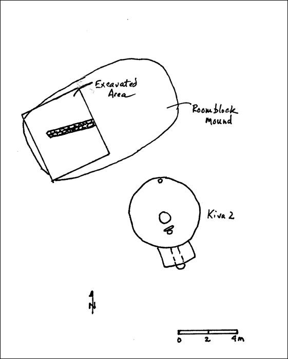 |
Plan Map of Area 2, 5MT2 (pdf format) |
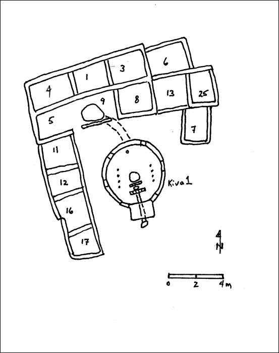 |
Plan Map of Area 1, 5MT2 (pdf format) |
The latest component at 5MT2 comprises a single 14 room pueblo and kiva that are located just 25 m north of the first component. The occupation of this larger pueblo is placed sometime between A.D. 1200 and 1280 based on ceramic type frequencies, architectural style, and one archaeomagnetic date. There are several dated dendrochronological samples from this area of the site which suggest a construction date in the late twelfth century, but we argue that these may actually represent salvaged timber from the earlier component of the site.
The pueblo in this northern component was built in two to three construction events. The original pueblo consisted of six rooms and eventually expanded to 14 rooms with the addition of four rooms to the east and a line of four southern rooms attached on the west end. The overall pattern is that of an "L" shaped roomblock with a kiva and plaza in the middle. The kiva likely served primarily as a domestic structure, but may have sponsored local ceremonial events based on the presence of two tunnels into the structure, as well as possible locations for setting up altars. The number of rooms, the presence of at least three living rooms with substantial hearths, as well as a deep, well-built kiva, allow for an site population estimate of at least two to three households.
The pueblo was abandoned in a very purposeful way with numerous whole vessels left behind in one of the surface living rooms and the kiva. The roofs of a number of the structures collapsed onto the floors of the structures very soon after abandonment. There is no evidence of violence in the abandonment, but it likely that the inhabitants were moving a considerable distance from the region, based on the very intentional and orderly nature of the abandonment assemblage and the large numbers of tools left behind.
History of Research
Field research at 5MT2 was conducted as part of the CU Museum's summer archaeological field schools between 1986 and 1988. Field research was technically overseen by Dr. Fred Lange, but in large measure the research design and fieldwork were supervised by a graduate student, John Cater.
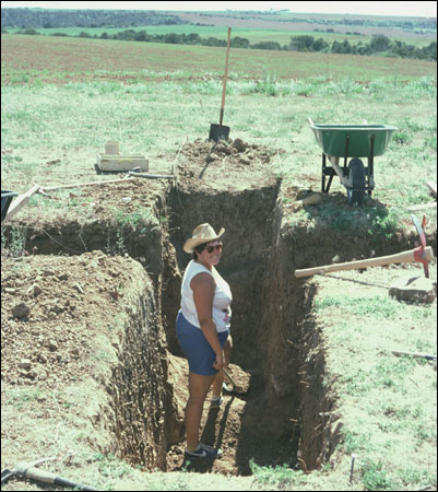 |
North-south and east-west cross-section trenches through Kiva 2, Area 2, 5MT2 (SL-YJ-JC-004) |
In 1987, the second summer field season expanded excavations in the structures exposed by the 1986 exploratory trenches. In Area 1 or the latest component at the site, units were opened in Rooms 1, 3, 4, 5, 6, 7, 8, and 9 and the quadrants remaining in Kiva 1 were excavated and portions of the floor were exposed. In the early component in Area 2 the main fill of the kiva was removed and about one-third of the roomblock area was exposed. Given the massive prehistoric dismantling that occurred in these southern structures, rooms were more difficult to define and work went a bit more slowly. Two large 1 m by 8 m exploratory trenches were excavated in the midden to the southeast of the northern roomblock in order to better understand the overall site history. The 1987 field season also saw CU field schools in archaeoastronomy and site survey, but they remained largely separate from the 5MT2 field school.
The final summer season of work at the site (1988) witnessed the completion of excavations in the structures exposed in the 1987 season. The 1988 work also exposed the floors of Rooms 11, 12, 13, 16, 17, and 25 in Area 1 (the northern roomblock) as well as exploratory excavations in the plaza around the north, west, and south edges of Kiva 1. In Area 2 (the southern roomblock) approximately two-thirds of the roomblock area was excavated and Kiva 2 was completed.
Much of the analytical research on 5MT2 was done by John Cater for his MA thesis. He primarily focused on diagnostic ceramic types and items found on structural surfaces. As with all of the Yellow Jacket collections, only a small fraction of the artifact collection from 5MT2 has been subject to a systematic laboratory analysis. The collection is immense and was too large to be reported in a single MA.
Available Documentation
In discussing our work on the Yellow Jacket project with other archaeological researchers, we have often been struck by the number of people unaware of the excavations at 5MT2. There seem to be two reasons for this. First, the work at the Yellow Jacket sites is so heavily identified with Joe Ben Wheat that most people think of those sites where he directed the excavations (i.e., 5MT1 and 3) as representing all the work at Yellow Jacket. Secondly, the fieldwork at 5MT2 was primarily reported on in a master's thesis (Cater 1989Cater, John D.
1989 Chronological Understanding of Site 5MT2, Yellow Jacket, Colorado, and a Study of Abandonment Modes. Unpublished MA thesis, Department of Anthropology, University of Colorado, Boulder.) and unfortunately student theses often become part of archaeology's "gray literature." Consequently, the references to 5MT2 in the published literature are usually limited to very brief remarks commenting on its relationship to the other sites in the Yellow Jacket locale.
There are field notes for all three seasons of work. John Cater's crew chief notes offer a good overview of the work occurring at the site and the field school student notes account for the work in specific excavation units. A basic listing of the excavation notes is presented in the table below. For each year there are also field catalogs and laboratory inventory sheets. In addition, there are also some of Cater's ceramic analysis forms and a limited analysis of lithic tools as well.
| Name | Period Covered | Comment (Units Covered) | John Cater | 6/1/86-8/15/86 | Crew chief notes |
|---|---|---|
| Kristin Cook | 6/18/86-8/10/86 | Area 1: TUs 2, 6, 12; EUs 16S 0E, 16S 2W |
| Minette Church | 6/17/86-8/10/86 | Area 1: TUs 1, 3, 17, 18; EUs 2S 3E |
| Andrew Granitto | 6/23/86-8/9/86 | Area 1: TUs 7, 8, 10, 16; TUs 3W, 1 E, 2W |
| Leigh Ferreira | 6/18/86-8/9/86 | Area 2: TUs 1, 5, 6, 7; EUs 38S 2W, 36S 2W, 36S 4W |
| Jeanette Mobley | 6/17/86-8/10/86 | Area 2: TUs 3, 4, 8 |
| Kevin Gilmore | 6/18/86-8/14/86 | Area 2: TU 2; soils study |
| John Cater | 5/25/87-7/28/87 | Crew chief notes |
| Patricia Tomlinson | 6/3/87-8/6/87 | Area 1: EU 2, TU 1W, TU 5 |
| Khang Le | 6/3/87-8/4/87 | Area 1: EUs 2, 3, 4, 8 |
| Jose Vasquez | 6/5/87 | limited 5MT2 notes |
| James Salter | 6/3/87-6/19/87 | Area 1: EU 2, TU 1E |
| Nancy Malville | 6/28/87-7/22/87 | Area 1: TUs 3A1-4, 3B1-2, EU 10 |
| Susan Kepecs | 6/3/87-7/10/87 | Area 1: EU 2; Area 2: EU 1, 3, 38S 2W |
| Darcey Delaney | 6/3/87-7/26/87 | Area 1: EUs 2, 4, 9 |
| Cynthia Webb | 6/3/87-8/4/87 | Area 1: EU 2; Area 2: TUs 1W, 7N, 8; EUs 2, 2NW, 2SW, 2NE |
| Ken Boden | 6/3/87-7/7/17/87 | Area 1: EU 2, 2NE, 2SW; TUs 4, 5, 11 |
| Donna Bryant | 6/3/87-7/30/87 | Area 1: EUs 2, 5, 11 |
| John Cater | 6/21/88-8/4/88 | Crew chief notes |
| Scott Somers | 6/20/88-7/29/88 | Area 1: EUs 19, 21, 23 |
| Kelly McAndrews | 6/8/88-8/2/88 | Area 1: EUs 12, 14, 16; some Susan Yuhaz notes in this section as well |
| Abe Friedman | 6/21/88 | Area 1: EU 20 |
| Lorrie Hulston | 7/17/88-7/28/88 | Area 1: EU 22 |
| John Foster | 6/20/88-8/5/88 | Area 1: EUs 15, 25 |
| Cynthia Webb | 7/2/88-8/1/88 | Area 2: EU 4 |
| Patricia Tomlinson | 6/21/88-late July | Area 1: EU 2 |
| Patricia Dahnke | 6/20/88-8/3/88 | Area 1: EUs 17, 24 |
| Amy Rogel | 6/20/88-8/1/88 | Area 1: EUs 2, 18 |
| Donna Bryant | 8/1/88-8/8/88 | Area 1: EU 26 |
| K. Burt & D. Bowman | 6/8/88-6/23/88 | EU 13 |
There are small sketch maps scattered throughout the notes, as well as some maps gathered in the crew chief notes for each year. There is a useful sketch map that appears in the notes that lays out all the various units in both areas of the site. Although black and white photos and color slides were taken in the field, these have not been found in the Museum. The photos and slides used in this report were scanned from images borrowed from Jeannie Mobley-Tanaka and John Cater, who both worked at the site and who gave the Museum permission to use them in this report.
Provenience Designations
There are three basic forms of provenience designation for 5MT2: test units (TU), excavation units (EU), and grid units (e.g., 36S 2W). In the first year the majority of the units were excavated as test units, or 1 m by 2 m test pits linked together in a 36 m long north-south trench through Area 1, and a 16 m long trench through Area 2. The midden area was also excavated in test units. Unit numbers were assigned as units were opened up. So, for example, the trench cutting through Area 1 begins with TU 3 as the northernmost unit, with TU 1 next to the south, and then TU 18, and so forth. The only sequence is in the time of assignment of the numbers, not in their location at the site.
Excavation units tend to be more arbitrarily defined, and oftentimes are used to define irregular spaces such as within structures. In the case of the roomblocks and kivas, the EU numbers for these structures were thereafter used as the number for the structure (with a few key exceptions). So EU 3 in Area 1 is Room 3 in Cater's MA thesis and in this report. The kivas provide an exception to this rule in that they were both EU 2 (but in different areas), but in this report they are designated as Kiva 1 for the Area 1 kiva, and Kiva 2 for Area 2.
A steel rebar was set into cement at the north edge of the northern roomblock and was arbitrarily given a "0S 0W" designation. At times grid units were used to excavate difficult to define surface rooms, such as in Area 2, or to excavate plaza units.
There are cases at 5MT 2 where one type of provenience assignment, such as a grid unit, is later replaced by another provenience designator, such as an EU number. For example, 36S 2W in Area 2 is also designated EU 1 within the roomblock area. In cases such as this, the specific excavation notes and various sketch maps are useful at untangling any possible confusions.